


Le Val des Nymphes

alinetpierre
User

Length
12.4 km

Max alt
232 m

Uphill gradient
259 m
Km-Effort
15.8 km

Min alt
80 m

Downhill gradient
266 m
Boucle
Yes
Creation date :
2023-04-09 07:53:35.0
Updated on :
2023-04-09 10:56:21.117
2h46
Difficulty : Easy

FREE GPS app for hiking
 SityTrail
IGN / Geographical institutes
SityTrail Plus
The world is yours!
About
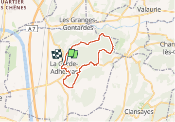
Trail Walking of 12.4 km to be discovered at Auvergne-Rhône-Alpes, Drôme, La Garde-Adhémar. This trail is proposed by alinetpierre.
Description
Très belle randonnée , de l’ombre, de l’eau
Photos


Positioning
Country:
France
Region :
Auvergne-Rhône-Alpes
Department/Province :
Drôme
Municipality :
La Garde-Adhémar
Location:
Unknown
Start:(Dec)
Start:(UTM)
639791 ; 4917195 (31T) N.
Comments